
Aberystwyth, Ceredigion, Wales.
Written by Steve Hall
Below is an assessment of an area just South of Aberystwyth I have known of for many years. Tan-y-bwlch is a beautiful area and one that has biodiversity, geomorphological, and recreational benefits to offer the people of the area. The enclosed essay is one that I carried out for the University of Brighton back in 2019, and which has since gained greater significance as the area has continued to experience enhanced coastal erosion and review by the local authorities concerning its status and future.
Introduction.
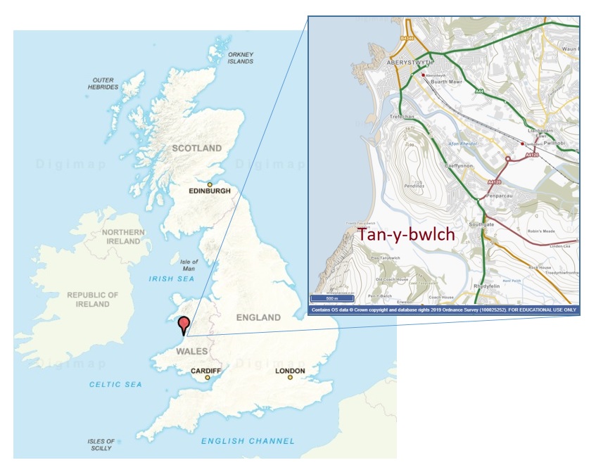
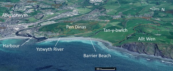
Located immediately south of the town of Aberystwyth on the coast of Mid-Wales (Figure 1), Tan-y-bwlch is a gently sloping valley with a managed shingle barrier system on its Western edge. The shingle beach provides protection from marine intrusion during high tides and storm events, and is designated as a Site of Special Scientific Interest (SSSI) due to the flora found here. Bounded to the south by Allt Wen, a SSSI because of the geology exposed in the eroded cliff face, and to the north by Pen Dinas (AKA Monument) Hill which has been a Nature reserve since 1999, (and encompasses an Iron Age Hillfort, Scheduled monument, and ancient midden) (Figure 2).
The Ystwyth River flows through Tan-y-bwlch, with the last ~ 700 m of the river flowing immediately behind the shingle beach barrier to discharge through Aberystwyth harbour in an attempt to increase discharge and minimise sediment accretion. Tidal influence on the Ystwyth River extends ~ 900m in to Tan-y-bwlch, but through management practices in the form of a flood bank, this ingress is retained within the river channel and does not extend past the river banks.
With Tan-y-bwlch’s close proximity to the areas major conurbation, yet separated from it by Pen Dinas, the valley offers a unique aesthetic recreational and environmental opportunity for the area. The geological history of the area, with it being heavily influenced by glaciation and then subsequently through mining throughout the catchment of the river, has produced a valley floor of alluvium (British Geological Survey, 2019).
Source: Modified from Google Maps
.
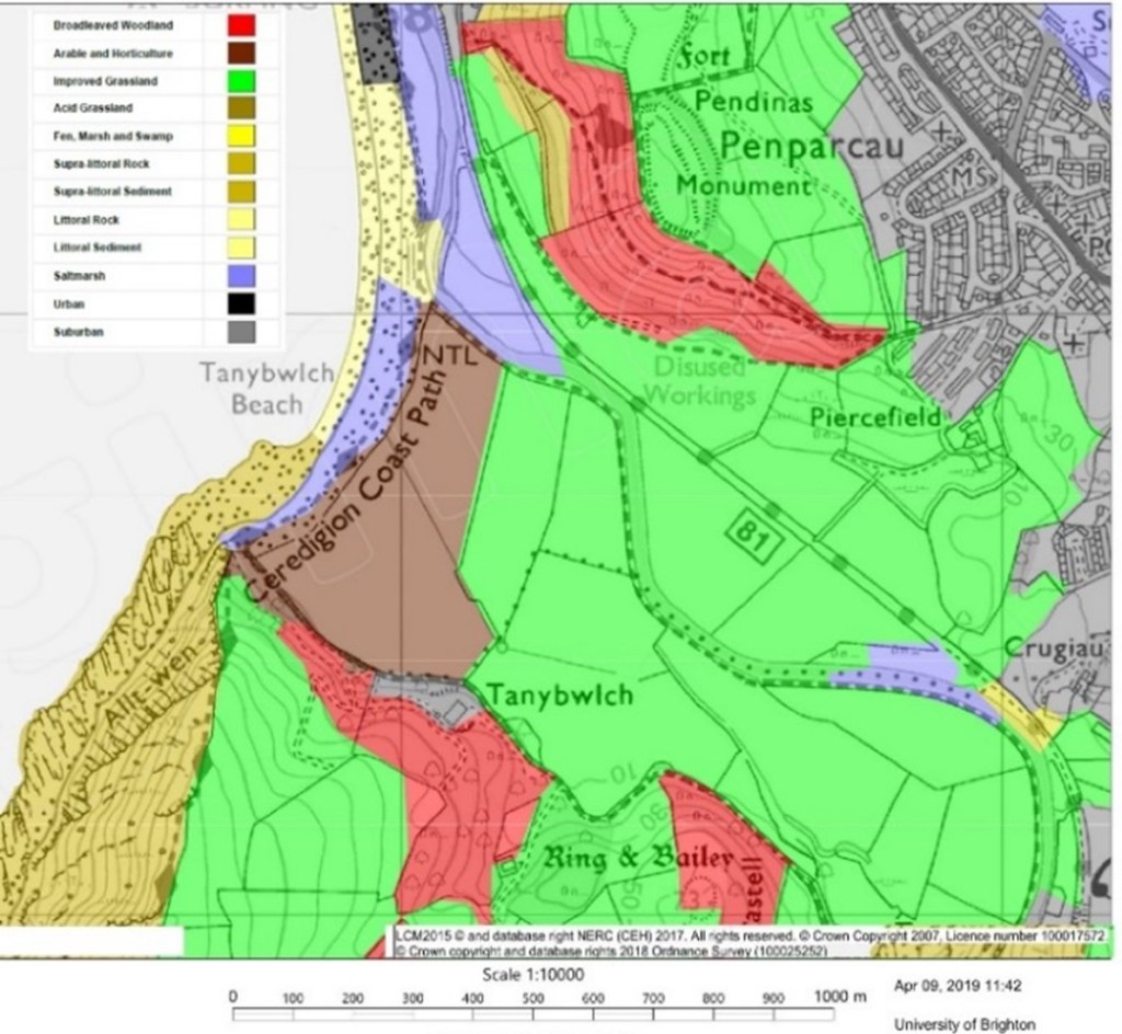
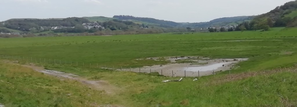
Tan-y-bwlch valley floor totals ~ 108ha with saltmarsh found at the Western extreme on the landward side of the beach barrier and in two areas of the northern bank of the Ystwyth River. Fen marsh can be found in a small area (~ 0.4 ha) at the Western extreme of the valley, bordered by the Ystwyth River and the disused railway line. The vast majority of the valley floor however is taken up by ‘improved grassland’ (Figure 3), which has been grazed by sheep, cattle and horses, with evidence of historic arable cultivation evident in the form of ridge and furrow formations to the Eastern end of the valley. Identified as ‘Acid Grassland’, the temporally distant evidence described above for arable agriculture is the only signs of any arable farming (Pethick et al, 2003).
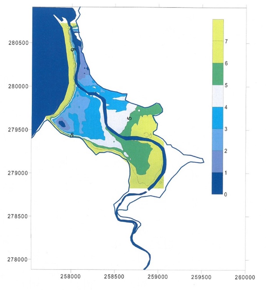
Hydrology for Tan-y-bwlch is dominated by high precipitation, with saline ingress from infiltration of the beach barrier system and salt spray also being a consideration. Topography of the valley is gently upward sloping landward (eastward) from a surface elevation of 0m above OD (ordinance datum), to ~ 7m above OD at the Eastern extent of the valley, with a single main irrigation ditch running the length of the valley. Due to the low elevation, particularly in the South Western area of the valley (Figure 4) standing water in the form of an ephemeral shallow pond is present for extended periods of the winter months (Figure 5 &6).
Annual rainfall averages for the years 1981 – 2010 show Aberystwyth experiencing 1074.7mm/year of rainfall (metoffice.gov.uk), with the Ystwyth River catchment covering an area of 193 Km2 (South West Wales River Authority, 1970). The catchment includes peat bogs, agricultural areas, and disused copper, lead, and zinc mines, producing river discharge that fails EU drinking water directives regularly (Edwards and Murphy, 2015).
Managed repairs and maintenance to the South bank of the Ystwyth River ensures that both freshwater and brackish tidal waters do not currently intrude on to the valley floor south of the Ystwyth River. North of the river, at its lower reaches, are however tidally inundated producing salt marshes in this area. Projected sea level rise during the 21st century may increase the frequency and magnitude of both fresh and brackish water flooding throughout Tan-y-bwlch (Cazenave et al, 2017).

.
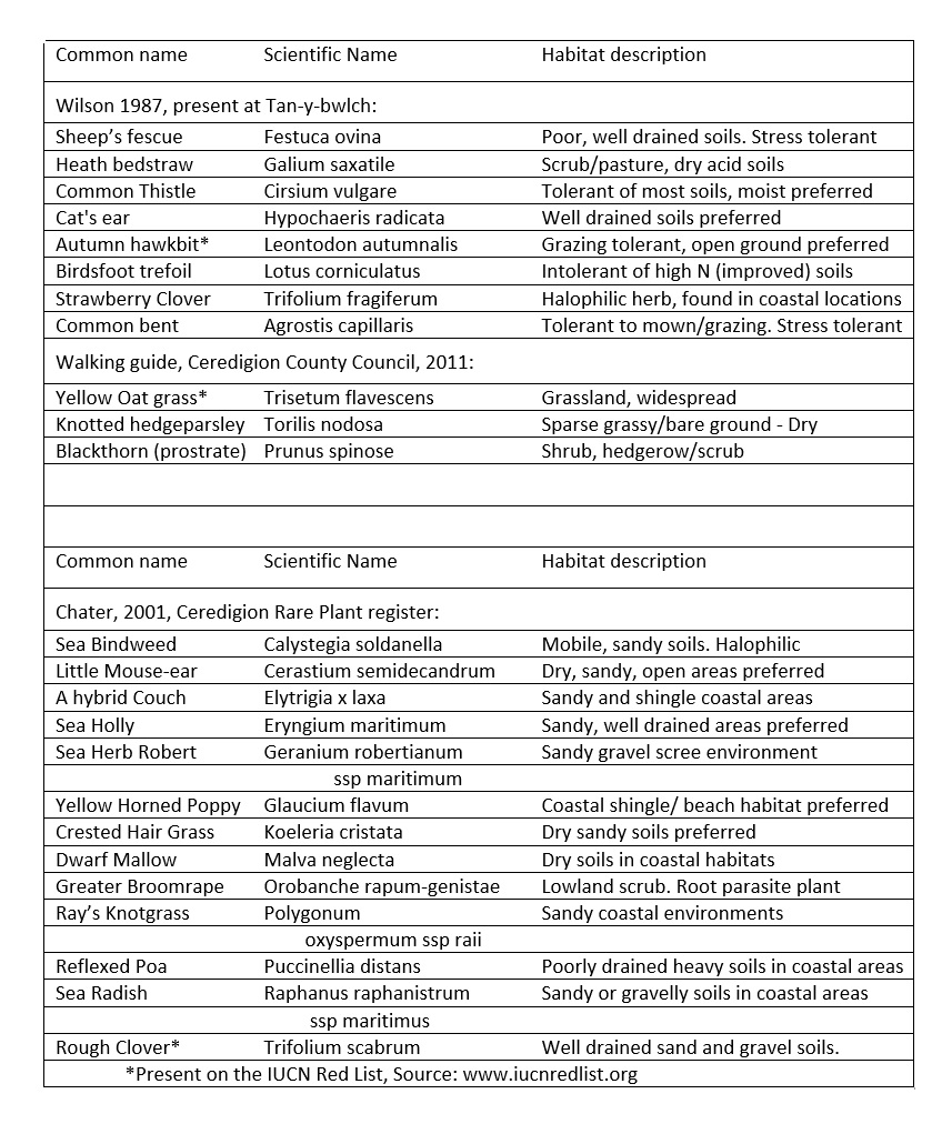
Vegetation found in Tan-y-bwlch demonstrates a varied soil and hydrology regime, with Festuca ovina (Wilson, 1987) demonstrating the presence of well drained, poor nutrient soils, to Puccinellia distans (Chater, 2001) which prefers heavy, poorly drained soils (Table 1). Specific zonation exists within the valley, such as riverbank, salt marsh, and mobile sandy beach barrier, with the majority of Tan-y-bwlch being managed pastoral land, which is dominated by hardy grass species (Figure 7). Additional features of Tan-y-bwlch’s unique environment lie in the metal contaminants within the Ystwyth River from historic mining activities within its catchment, and the saline intrusion from its coastal location, all producing an area of diverse flora contained within a relatively small valley.
Source: Modified from Wilson, 1987; Ceredigion County Council, 2011; Chater, 2001.
Whilst the majority of Tan-y-bwlch is ‘improved agricultural’ land used for grazing, the presence of Lotus corniculatus (Wilson, 1987) which is intolerant of nitrogen rich soils suggests limited artificial improvement of the soils within the valley, and this is corroborated by the lack of modern evidence for arable farming (Pethick et al, 2003), confirming grazing being the dominant activity.
.
As well as being surrounded on three sides by SSSI’s and a nature reserve, the Tan-y-bwlch valley also has immense recreational benefit to the Aberystwyth area and Wales at large, with Tan-y-bwlch beach barrier forming a part of the Wales Coastal Pathway. The valley also has the disused Great Western Railway (Carmarthen to Aberystwyth) line running through it, providing recreational and aesthetic access to the area from the conurbation of Aberystwyth, as well as specific ‘disused railway’ environmental habitats.
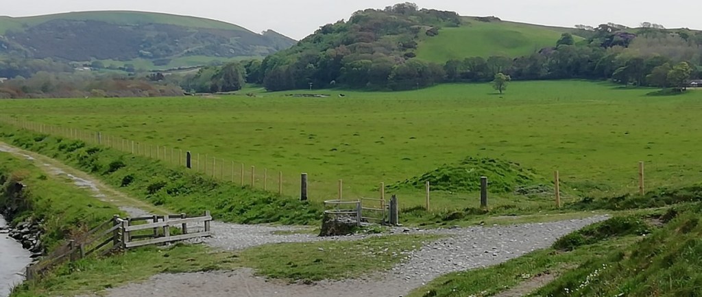
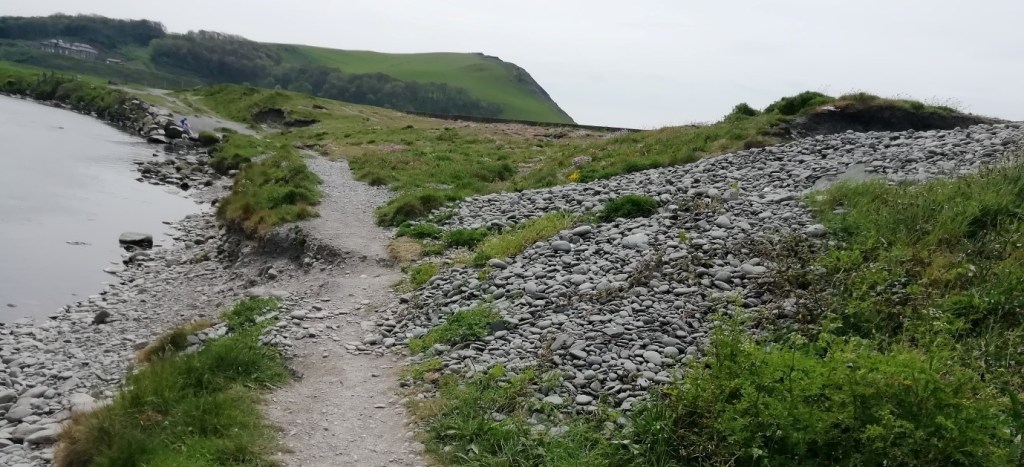
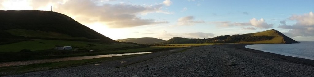
Engineered management of the Ystwyth River combined with the concrete reinforcements at the juncture of the River and the Shingle beach barrier, have produced and maintained the artificial valley hydrology. Evidence of erosional processes trying to produce a breach within the beach barrier are evident from both landward and seaward sides of the beach barrier (Figure 8 & 9).
Historical maintenance and reinforcement of the beach barrier system has been at the heart of the local authority’s coastal management plan. This has been based on an assumption that northward sediment migration along the Tan-y-bwlch beach would nourish beaches further North in the Aberystwyth littoral cell, as well as ensuring the discharge of the Ystwyth’s flow through Aberystwyth Harbour, thus encouraging scour and maintaining water depths in the harbour entrance (Wallace Evans & Partners, 1983). The predicted sediment transport and scour of the harbour have been brought in to question however in a study by Pethick et al (2003), which demonstrated a fragmentation of the Aberystwyth littoral cell in to individual components, of which Tan-y-bwlch beach has become a self-contained cell.

Site Evaluation and objectives
Due to the raised nature of the disused railway line which traverses the Northern and Eastern boundary of Tan-y-bwlch, the valley floor south of this artificial barrier, ~ 108 ha, would be the area affected by any attempt to alter this wetland environment, and is the only area under scrutiny in this report. Besides footpaths and the Ystwyth River, the entire area under examination is pastoral agricultural land. The frequent flooding of the area, particularly the South West corner of the valley floor, and the salinity of the pasture due to its close proximity to the sea, the land could be defined as low grade pasture. Construction and maintenance of the Southern river bank of the Ystwyth has ensured constriction of the Ystwyth’s discharge within the river channel, and prevented overtopping and flooding of the valley floor. In addition to this engineered barrier, drainage ditches within the previous floodplain have accelerated and facilitated drainage of the area south of the river. Drainage within the area given over to pasture flows seaward with a sluice drain passing beneath the beach barrier system and allowing drainage in to the sea.
Surrounded as it is by designated and protected sites (SSSI, Nature Reserve, and Scheduled Monument), the Tan-y-bwlch valley has become an area frequented and enjoyed by Ceredigion residents as well as many of the large number of tourists that visit the area each year. With the Welsh Coastal Pathway, Nature walks, and the cycle/walk track along the disused railway, the valley has become an integral part of the Ceredigion portfolio of natural assets. The valley in its current condition does not act as a detractor to the Nature Reserve immediately North, or the SSSI (flora) to the immediate West, but neither does it encourage or expand the biodiversity of the area. The limited area of existing Salt Marsh in the valley, and absence of a coastal lagoon, detract from the possible ecoservices potential of the area, and with these being priority habitats under Annex 1 of the Habitat Directive (EU Directive, 1992), suggests an opportunity to develop the areas biodiversity is being missed. Catchment for the Ystwyth River includes areas of historical mining, and the subsequent legacy of heavy metal pollutants is still evident within the Ystwyth discharge (Edwards and Murphy, 2015). This level of pollution has produced unique environments in the upper reaches of the River Ystwyth’s course, with environmental niches supporting heavy metal tolerant species (Johnson et al, 1978). These pollutant tolerant species have not been found within Tan-y-bwlch, but this would be expected due to the confined and restricted course of the River through Tan-y-bwlch.
Local authority policy over the preceding decades has been to maintain the integrity of the beach barrier defences at Tan-y-bwlch which has maintained the status quo regarding the hydrology of the valley. As discussed earlier, studies now suggest that the maintenance of the beach barrier system has no impact upon the coastal defences of the greater Aberystwyth coastline (Pethick et al, 2003), and therefore the ongoing costs of maintaining the beach barrier structure from breaching are unnecessary.
With sea level rise accelerating when compared to early 20th century rates (Cazenave et al, 2017), and currently at 3.2 mm/Yr., continued defence of the Tan-y-bwlch valley and particularly the beach barrier structure will become increasingly untenable as no commercial or domestic structures are threatened with flooding in the valley, now or in the next 100 years (Pethick et al, 2003). Combined with sea level rise, the increase in storm severity and frequency predicted for the remainder of the 21st century (Bender et al, 2010) will exacerbate existing erosional processes and increase the costs to maintain the beach barrier system.
As the valleys agricultural land is privately owned, any future wetland management plan for the valley will have to take land ownership in to account and be an agreed approach between the administrative bodies concerned and the land owner. Commercial interests have historically taken precedence over environmental or biodiversity concerns for farmers globally (Turvey, 1991) and therefore any management plan for the area will have to overcome financial concerns from the land owner as well as maximising the environmental benefit of the area.
Alteration and enhancement to the hydrological regime of Tan-y-bwlch, particularly the area south of the river, would enable the development of a number of ecologically important habitats that are increasingly threatened both nationally and internationally. Reed beds and swamp conditions at the Eastern extremity of the valley could then transition in to wet grassland as you progress westward. Expansion of salt marshes and coastal lagoon habitats from the western end of the valley would then transition as elevation increased eastward. Equally important as the habitats described would be the transition zones in-between these habitats, allowing numerous unique environmental niches to develop.
Management plan & prescription
Minor changes to the south bank of the Ystwyth River, allowing periodic flooding of the Eastern topographically low areas of the valley would provide immense environmental habitat change with minimal costs involved. Alteration in two places, firstly at the Eastern extreme of the proposed area, and secondly at the Western end of the rivers course where it meets the beach barrier system (Figure 10), would produce two very contrasting wetland environments. Either, or both, change to the river bank could be actioned with no dependency between them.
Managed inundation of freshwater to the Eastern end of the valley would provide the hydrology to ensure wet grassland would continue to thrive in this area. Topographically constrained, the groundwater level could be easily managed with the consistent year round flow of the Ystwyth to produce the required hydrological regime. Introduction of reed beds at the river discharges initial intrusion in to the valley would expand the habitat types within the valley, and act as a possible filtration system for the heavy metal contaminants within the water from upstream sites of pollution.
A breach could be made at the Western end of the valley, by the South bank of the river being lowered to the valley floor level just before the point at which the river meets the beach barrier system which in this area is ~ 2.76m OD. The river here is within tidal influence of the highest Spring tides, therefore when the river is at bank-full stage or during Spring Tide High Water, an area of ~ 10ha would be flooded with brackish waters. This would produce an extended salt marsh area and coastal lagoon (Figure 11), both key habitats under Annex 1 of the Habitat Directive (EU Directive, 1992).

Source: Pethick et al, 2003.
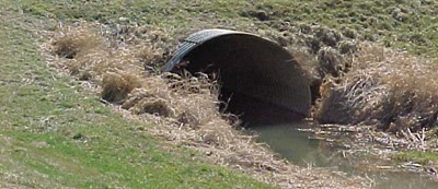
If a culvert were used to produce the breaches discussed through the bank of the Ystwyth (Figure 12) then continued use of the current pathway would still be viable. This would avoid resistance to change from current local users of the pathway, and also ensure continuity of the existing bank system as a migratory route for terrestrial species. Positioning of the elevation of the culvert could also help to manage the frequency and magnitude of flooding by positioning its height within the bank at a level equal to the flood level of the river which best matches the areas hydrological requirement.
Continued maintenance and support of the beach barrier system has been shown to be unjustified on environmental and coastal protection grounds (Pethick et al, 2003). Therefore, the cost savings of not sustaining the beach barrier system could be diverted to help and support the land owners of Tan-y-bwlch to graze the valley in a sustainable and less intensive way and compensate them for the reduced grazing available due to the extended flooding (Wynne-Jones, 2013). Shifting grazing from sheep to solely cattle and horses would also promote biodiversity and produce a less heterogeneous environment thus allowing niches to develop for differing plant species (Menard et al, 2002).
With funding removed from maintenance of the beach barrier system, it has been estimated that overwash chutes, and eventually a breach would occur in the beach barrier. This would not fundamentally alter the volume of flooding but may increase the salinity of the brackish water present, whilst not reducing excessively the habitats or harming the recognised species currently present within the SSSI, Pectenogammarus planicrurus (Welsh Government, 2014; Pethick et al, 2003). Predicted sea level changes through the 21st century (Cazenave et al, 2017) will continue to inflict pressures upon local authorities within the United Kingdom and Globally, and by adopting this management plan it will enable the local authorities to absorb any sea Level change, and the subsequent coastal defences that would require, for this stretch of coastline with no threats to buildings or infrastructure.
Natural succession in the valley, once the river bank and grazing regime is altered, would cause incised channels to appear in the existing soils with salt marsh vegetation colonising non-channel areas. With no anthropogenic input to this process it may take decades for the salt marsh, wetland fringe habitats and coastal lagoon to become established, but those species present will have developed naturally and thus produce a much more robust ecosystem. Alternatively, engineered alterations to the valley floor could potentially accelerate colonisation and development of the valley. Reducing drainage capability at the Eastern end of the valley would reduce water flow, and ensure a maintained water level is more widespread. At the western end of the valley, removal of the existing drainage sluice through the beach, and creation of shallow channels which tidal flooding could then develop would encourage and maximise colonisation.
Monitoring of the development of Tan-y-bwlch wetlands could be achieved in the form of annual surveys of birds, flora and fauna. As was demonstrated in the adjacent Pen Dinas Hill nature reserve during its formation in the late 1990’s, the local populations’ enthusiasm and desire to be involved could be harnessed to both aid in the annual surveys as well as to monitor day to day activity. As the Pen Dinas, Tan-y-bwlch, and Allt Wen areas are already a popular area with the residents and visitors to the area, to formalise and expand the aesthetic and ecological significance of the area for visitors should be a straight forward process and one which would greatly increase the wetland management plans chances of success.
Summary
Bounded by Sites of Special Scientific Interest and a Nature Reserve, Tan-y-bwlch is an area of immense natural beauty which has seen little intensive agricultural development and almost no residential or commercial intrusion. Currently separated from the marine environment by a beach barrier system that is maintained and supplemented by the local authority, research has shown that the perceived benefits of this configuration are no longer valid and that continued reinforcement of the beach defences are no longer economically justified.
With minimal changes to the topography of the valley, and grazing regimes for local land owners, an area that already boasts salt marshes, fens, and grasslands, could expand the wetland areas present considerably. The return of parts of the Tan-y-bwlch valley to extensive salt marshes and coastal lagoons would not only expand the biodiversity of the area, it would also both support and benefit from ecological synergies with the neighbouring nature reserve (Figure 13).
Tan-y-bwlch is an area of unspoilt nature which is in close proximity to the largest urban conurbation in Mid-West Wales. Already frequently visited by residents and tourists alike along the Welsh Coastal Path and the cycle/walk path of the disused railway line, expansion of the wetland habitat would provide greatly improved ecological, aesthetic and recreational services to visitors, and produce a diverse ecologically rich range of wetlands.
Source: S. Hall.
References
Bender, M.A., Knutson, T.R., Tuleya, R.E., Sirutis, J.J., Vecchi, G.A., Garner, S.T. and Held, I.M., 2010. Modeled impact of anthropogenic warming on the frequency of intense Atlantic hurricanes. Science, 327(5964), pp.454-458.
British geological survey. 2019. Geology of Britain Viewer. [Online]. [10 May 2019]. Available from: http://mapapps.bgs.ac.uk/geologyofbritain/home.html
Cazenave, A., Chambers, D., Champollion, N., Dieng, H., Llovel, W., Forsberg, R., Schuckmann, K. and Wada, Y., 2017. Evaluation of the Global Mean Sea Level Budget between 1993 and 2014. Surveys in Geophysics, 38(1).
Chater, A.O., 2001. Ceredigion (VC46) Rare Plant Register.
Edwards, P. and Murphy, F., 2015. Managing the Environmental Legacies of Frongoch Lead and Zinc Mine. Mining History, 19(3).
EU Directive, 1992. Council Directive 92/43/EEC of 21 May 1992 on the conservation of natural habitats and of wild fauna and flora. Official Journal of the European Union, 206, pp.7-50.
Johnson, M.S., Putwain, P.D. and Holliday, R.J., 1978. Wildlife conservation value of derelict metalliferous mine workings in Wales. Biological Conservation, 14(2), pp.131-148.
Johnson, M.S., Putwain, P.D. and Holliday, R.J., 1978. Wildlife conservation value of derelict metalliferous mine workings in Wales. Biological Conservation, 14(2), pp.131-148.
Menard, C., Duncan, P., Fleurance, G., Georges, J.Y. and Lila, M., 2002. Comparative foraging and nutrition of horses and cattle in European wetlands. Journal of applied ecology, 39(1), pp.120-133.
Metoffice. 2019. Met Office – Climate Summaries. [Online]. [10 May 2019]. Available from: https://www.metoffice.gov.uk/climate/uk/summaries
Pethick, J., Orford, J., and Young, R., 2003. Allt Wen a Traeth Tan-y-nwlch SSSI and Aberystwyth Frontage, Nature Conservation Strategy. Countryside Council for Wales and Cyngor Sir Ceredigion.
South West Wales River Authority, 1970. First Water Resources Survey: Report. December 1970. Accessed 12 April 2019 http://ea-lit.freshwaterlife.org/archive/ealit:3463/OBJ/20002476.pdf
Turvey, C.G., 1991. Environmental quality constraints and farm-level decision making. American Journal of Agricultural Economics, 73(5), pp.1399-1404.
Wallace Evans Ltd. 1994. Mike 11 modelling of existing and predicted flood levels. Aberystwyth Harbour development.
Welsh Government. 2014. Report to the National Assembly for Wales on Marine Protected Areas in Wales. Accessed 11 April 2019 https://llyw.cymru/sites/default/files/publications/2018-05/adroddiad-ar-ardaloedd-morol-gwarchodedig.pdf
Wilson, J.B., 1988. The cost of heavy-metal tolerance: an example. Evolution, 42(2), pp.408-413.
Wynne-Jones, S., 2013. Ecosystem service delivery in Wales: evaluating farmers’ engagement and willingness to participate. Journal of Environmental Policy & Planning, 15(4), pp.493-511.
